Digital Landslide Inventory for the Cowlitz County Urban Corridor
In this demonstration in a recent presentation to the Oregon Academy of Sciences, spatial data was obtained from Cowlitz County, located within the State of Washington. These data consists of three layers, taxlots, street centerlines and a 2006 one-meter raster image. The software used to do the work is ESRI ARCGIS 9.1 for making the base map and Imagemapper (version 10 with AJAX) used for adding functionality to the map.
A combination of the two software make the relatively inexpensive raw data look and perform more dynamically and responsive, a robust desktop application, but with all the information content of the Internet behind it.
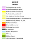
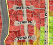
The example used is the Digital Landslide Inventory for the Cowlitz County Urban Corridor, located within the State of Washington. A landslide study by Karl W. Wegmann in 2006 developed a digital, map-based, geographic information systems (GIS) inventory and database for identified deep-seated and shallow landslides within the Cowlitz County urban corridor. The study also delineated features such as escarpments, and shallow and deep-seated landslides. Geo-spatial data and a small-scale county maps were produced and made accessible to the public on the Internet. Although the inventory and related documents are publicly available, use and interpretation of the information has been challenging for the public.
|