| |
| Home |
| Technology |
| Features |
| Content |
| Examples |
| Contact |
| Content |
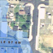
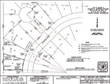
Taxlots: Provide maps that can be used to determine the approximate location of parcel lines. The important map feature is that the lines appear scaled with an air-photo overlay. Interpreting the relative location of a lot line is simple with photographic references. General Landuse and Zoning: The user can find any parcel and with it, current land use and zoning. The map is linked to the pertinent sections of city or county land use and zoning ordinances. Parcel information is also supplied by a link to existing county databases. Its simple, search first or click on a parcel to look at the current land owner. You can search for parcels by names, numbers or address. Surveys and Land Documents: Because there have been requirements made to land developers regarding surveys, this application allows the user to browse copies of all available surveys for each lot. Through the map interface, the user can easily see what lots have been surveyed and which have not. One click of the mouse opens the survey so it can be used. The Cartomation GIS application utilizes spatial data in an environment whereby databases, HTML pages, and land use documents are indexed and accessed through the map. The Cartomation GIS application utilizes a collection of thousands of pre-prepared custom maps organized into themes tailored to meet the needs of the county department. Because the maps exist as tiles, they can be quickly and efficiently drawn on the users computer screen. Alternatively maps don’t exist until the user makes a request, which takes more time. Contour Lines: Elevation is sometimes a challenging piece of information to find. The elevation of a lot or road can be best relayed by providing elevation information to construct a cross section, determine a spot elevation, derive a slope angle or contour. Land use cases: Land use cases that appear as a colorized transparency over selectable GIS layers. Each color indicates a specific land use case type. The user can search for case numbers, parcel numbers and read any related document by clicking on the map. Land use sub-types: The user can see categories of unique sub-types that appear as colorized transparencies over selectable GIS layers. Each color indicates a specific land use sub-type category. The user can search for case numbers, parcel numbers. |
| NEW MAPS | ||
|
||